Geospatial Imagery Analytics Market by Component, Type, By Collection Medium, By Application and By Region – Global Opportunities & Forecast, 2020-2027
Geospatial Imagery Analytics Market by Component (Solutions, Services), Type (Image-based Analytics, Video-based Analytics), By Collection Medium (Satellites, UAV, and GIS), By Application (Construction, Surveillance & Monitoring, Disaster Management, Research, Energy & Resource Management, and Others) and By Region – Global Opportunities & Forecast, 2020-2027
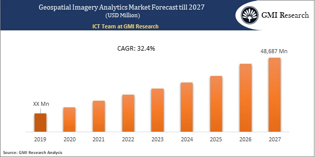
Geospatial Imagery Analytics Market is expected to rise at USD 48,687 Million by 2027 at a CAGR of 32.4% during the forecast period.
Introduction of the Geospatial Imagery Analytics Market Report
Geospatial imagery analytics comprises the compilation and analysis of geographic data that includes satellite photographs and historical information. It provides high-resolution geographic models to help understand the historical changes and estimate the underway shifts. Geospatial imagery analytics assist enterprises in boosting their decision making.
To have an edge over the competition by knowing the market dynamics and current trends of “Geospatial Imagery Analytics Market”, request for Sample Report here
Market Dynamic
Key Drivers and Emerging Trends
The factors driving the geospatial imagery analytics market growth are the proliferating demand for GIS services by the businesses for understanding the customer preferences to boost the sales in the specified targeted demography. Businesses deploy geospatial analytics solutions for enhancing their decision-making process. Furthermore, the government authorities are focusing on making disaster management efficient by analyzing the data generated by satellites and GIS to reduce the adverse impact of natural calamities, including earthquakes, floods, and extreme tidal waves. The border authorities invest heavily in satellite technologies to capture high-resolution geospatial images & videos to reduce cross-border terrorist activity and safeguard national security. The rapid adoption of GIS technology also supplements the growth of the geospatial imagery analytics market throughout the transportation and logistics sector. As the vendors in the transportation and logistics space look for cost-effective solutions to optimize fleet operations, geospatial analytics solutions help provide the data related to road conditions & traffic congestions.
Restraint in the Geospatial Imagery Analytics Market
Factors including growing legal issues and stringent regulationsare projected to hamper the global geospatial imagery analytics market growth over the forecast period.
Do you want to know more about the Research process and detailed Methodology, Request Research Methodology of this report
Type- Segment Analysis
The image-based analytics segment is projected to hold the largest market share in the global geospatial imagery analytics market based on the type. The capture of high-resolution images has progressively become simpler considering the different technological developments in satellite technology, steering the adoption of image-based analytics. The organizations are incrementally deploying efficient geospatial imagery analytics solutions to determine future risks and plan to tackle the situation.
Collection Medium- Segment Analysis
GIS holds the largest market share in the global geospatial imagery analytics market based on the collection medium. The GIS mapping tool aids in analyzing the geospatial data that is georeferenced utilizing any data, including the location that is defined based on latitude and longitude, zip code, or address. The growth of the market is attributable to the rising need for assistance in environmental management during natural disasters, hazards, and climatic changes. It is also deployed to identify the geographic patterns in data and visualize them on the map to analyze the contingency plans and future risks.
In case, any of your pain points areas are not covered in the current scope of this report, Request for Free Customization here
Regional – Segment Analysis:
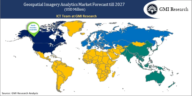
Based on the region, the North America region is expected to hold the largest market share over the forecast period in the global geospatial imagery analytics market. The region is a prime contributor to the market as it is technologically advanced in artificial intelligence, IoT, machine learning, and its integration with analytics. North America is the early adopter of advanced technologies throughout diverse applications, including construction, surveillance & monitoring, disaster management, research, energy & resource management, and others. The rising technological advancements and increasing adoption of connected devices supplement the adoption of geospatial solutions in the region.
Top Market Players
Various notable players operating in the marketincludeAlphabet Inc., Trimble Inc., Maxar Technologies, Harris Corporation, Hexagon AB, Microsoft Corporation, Oracle Corporation, TomTom N.V., Autodesk, Inc., and SAP SEamong others.
Key Developments:
-
- In 2020, Hexagon AB unveiled the launch of Luciad 2020 for delivering more powerful and faster 3D visualization and analytics capability and to extend their portfolio with LuciadCPillarin order to incorporate the advanced geospatial visualization & analysis solution in their applications.
Segments covered in the Report
The global geospatial imagery Analytics Market has been segmented on the basis of component, service, enterprise size, end user, and key regions. Based on component, the market is segmented into solutions and services. Based on type, the market is segmented into image-based analytics, video-based analytics. Based on collection medium, the market is segmented into satellites, UAV, and GIS.By application, the market is bifurcated into construction, surveillance & monitoring, disaster management, research, energy & resource management, and others.
For detailed scope of the “Geospatial Imagery Analytics Market” report request a Sample Copy of the report
Key questions answered in this research report:
-
- At what pace is global geospatial imagery analytics market growing? What will be the growth trend in the future?
- What are the key drivers and restraints in Geospatial Imagery Analytics Market? What will be the impact of drivers and restraints in the future?
- What are the regional revenues and forecast breakdowns? Which are the major regional revenue pockets for growth in the Global Geospatial Imagery Analytics Market?
- Which Type generated maximum revenues in 2019 and identifies the most promising during the forecast period?
- What are the various Application areas of Global Geospatial Imagery Analytics Market and how they are poised to grow?
- What companies are the major participants in this market and their business strategies, how does the competitive landscape look like?
|
Report Coverage |
Details |
| Market Base Year |
2019 |
| Market Forecast Period |
2020-2027 |
| Market Revenues (2027) |
USD 48,687 Million |
| Base Year & Forecast Units |
Revenues (USD Million) |
| Market Segment | By Component, By Type, By Collection Medium, By Application, By Region |
| Regional Coverage | Asia Pacific, Europe, North America, and RoW |
| Companies Profiled | Alphabet Inc., Trimble Inc., Maxar Technologies, Harris Corporation, Hexagon AB, Microsoft Corporation, Oracle Corporation, TomTom N.V., Autodesk, Inc., and SAP SEamong others, a total of 10 companies covered. |
| 25% Free Customization Available | We will customize this report up to 25% as a free customization to address our client’s specific requirements |
Market Segmentation
Global Geospatial Imagery Analytics Market by Component
-
- Solutions
- Services
Global Geospatial Imagery Analytics Market by Type
-
- Image-based Analytics
- Video-based Analytics
Global Geospatial Imagery Analytics Market by Collection Medium
-
- Satellites
- Unmanned Aerial Vehicle (UAV)
- Geographic Information System (GIS)
Global Geospatial Imagery Analytics Market by Application
-
- Construction
- Surveillance & Monitoring
- Disaster Management
- Research
- Energy & Resource Management
- Others
Global Geospatial Imagery Analytics Market by Region
-
- North America Geospatial Imagery Analytics Market (Option 1: As a part of the free 25% customization)
- North America Market by Component
- North America Market by Type
- North America Market by Collection Medium
- North America Market byApplication
- US Market All-Up
- Canada Market All-Up
- Europe Geospatial Imagery Analytics Market (Option 2: As a part of the free 25% customization)
- Europe Market by Component
- Europe Market by Type
- Europe Market by Collection Medium
- Europe Market by Application
- UK Market All-Up
- Germany Market All-Up
- France Market All-Up
- Spain Market All-Up
- Rest of Europe Market All-Up
- Asia-Pacific Geospatial Imagery Analytics Market (Option 3: As a part of the free 25% customization)
- Asia-Pacific Market by Component
- Asia-Pacific Market by Type
- Asia-Pacific Market by Collection Medium
- Asia-Pacific Market by Application
- China Market All-Up
- India Market All-Up
- Japan Market All-Up
- Rest of APAC Market All-Up
- RoW Geospatial Imagery Analytics Market (Option 4: As a part of the free 25% customization)
- RoW Market by Component
- RoW Market by Type
- RoW Market by Collection Medium
- RoW Market by Application
- Brazil Market All-Up
- South Africa Market All-Up
- Saudi Arabia Market All-Up
- UAE Market All-Up
- Rest of world (remaining countries of the LAMEA region) Market All-Up
- North America Geospatial Imagery Analytics Market (Option 1: As a part of the free 25% customization)
Major Players Operating in the Geospatial Imagery Analytics Market (Option 5: As a part of the Free 25% Customization – Profiles of 5 Additional Companies of your Choice)
-
- Alphabet Inc.
- Trimble Inc.
- Maxar Technologies
- Harris Corporation
- Hexagon AB
- Microsoft Corporation
- Oracle Corporation
- TomTom N.V.
- Autodesk, Inc.
- SAP SE
Frequently Asked Question About This Report
Geospatial Imagery Analytics Market [UP1506A-00-0620]
The factors driving the geospatial imagery analytics market growth are the proliferating demand for GIS services by the businesses for understanding the customer preferences to oost the sales in the specified targeted demography.
GIS holds the largest market share in the geospatial imagery analytics market based on the collection medium. The GIS mapping tool aids in analyzing the geospatial data that is georeferenced utilizing any data, including the location that is defined based on latitude and longitude, zip code, or address
Alphabet Inc., Trimble Inc., Maxar Technologies, Harris Corporation, Hexagon AB, Microsoft Corporation, Oracle Corporation, TomTom N.V., Autodesk, Inc., and SAP SEamong others are the top market leaders in Geospatial Imagery Analytics.
Geospatial Imagery Analytics market is anticipated to reach 48,687 million by 2027.
- Published Date: May - 2021
- Report Format: Excel/PPT
- Report Code: UP1506A-00-0620
Licensing Options
Single-User License:
The report is used by the purchaser (One Individual) only
Multi-User License:Report is shared with maximum 5 users (employees) including the purchaser of the purchasing corporation only
Corporate License:
Report is shared with unlimited user (employees) of the purchasing corporation only
The report is used by the purchaser (One Individual) only
Multi-User License:Report is shared with maximum 5 users (employees) including the purchaser of the purchasing corporation only
Corporate License:
Report is shared with unlimited user (employees) of the purchasing corporation only
Geospatial Imagery Analytics Market by Component, Type, By Collection Medium, By Application and By Region – Global Opportunities & Forecast, 2020-2027
$ 4,499.00 – $ 6,649.00
Why GMI Research

