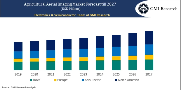
Agricultural Aerial Imaging Market by Application, End-Use, and by Region – Global Opportunities & Forecast, 2020-2027
Agricultural Aerial Imaging Market by Application (Aerial Photography, Data Acquisition and Analytics), End-Use (Monitoring, Resource Management, Seed Planting, and Others) and by Region – Global Opportunities & Forecast, 2020-2027
Agricultural Aerial Imaging Market is driven by rising need for advanced techniques in the agricultural process.
Agricultural Aerial Imaging Market Overview
Agricultural aerial imaging refers to the process of collecting aerial images of the specific field to identify potential crop-growing problems and enhance the productivity of the yields. The aerial images are captured using a satellite or a low altitude aircraft, such as a plane or a drone. It includes high-quality sensors and imaginary cameras, which captures a clear overview of the crop field and helps in resolving problems such as irregular irrigation, soil and field variation, pest and fungal infection.
To have an edge over the competition by knowing the market dynamics and current trends of “Agricultural Aerial Imaging Market,” request for Sample Report here
Major Agricultural Aerial Imaging Market Drivers
The primary factor contributing to the growth of the Global Agricultural Aerial Imaging Market includes the growing need for advanced techniques in the agricultural process driven by the increasing rate of population and the rising crop demand across the globe. The various government are launching initiatives to support domestic production capabilities of the crops which will encourage the farmers to opt for aerial imaging solutions to create crop management plans, perform seasonal analysis of the land, and to evaluate the impact of fertilizers. For instance, the National Agricultural Imagery Program (NAIP), which is administrated by USDA Farm Service Agency, is using agricultural aerial imaging solutions to provide orthoimages to the governments and public. On the other hand, the high initial investment and the requirement for skilled workers to translate the gathered data will hamper the growth of the market during the forecast period.
Do you want to know more about the Research process and detailed Methodology, Request Research Methodology of this report
Based on the application, the Global Agricultural Aerial Imaging Market is segmented into Aerial Photography, Data Acquisition, and Analytics. The aerial photography is expected to grow at a higher CAGR during the forecast period owing to the increasing adoption of aerial photography among the farmers across the globe. The aerial photography provides a bird’s eye view of the field while giving ample amount of data about the crops.
Based on the End-Use, the Global Agricultural Aerial Imaging Market is segmented into Monitoring, Resource Management, Seed Planting, and Others. The monitoring segment is anticipated to lead the market during the forecast period due to the increasing requirement of proper field analysis for enhancing crop productivity. The aerial imaging system is often used for monitoring the fields to find trouble areas within a farm before they are visible with the naked eye, thereby providing the ability to take pro-active actions to manage crop health.
In case, any of your pain points areas are not covered in the current scope of this report, Request for Customization here
Regional – Segment Analysis
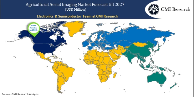
Based on the region, the North America region is anticipated to lead the market during the forecast period owing to the increasing investment on technological development for improving crop production across the region. The growing population rate is directly driving the demand for more crop production, thereby encouraging the end-users to opt for advanced devices such as aerial imaging systems to enhance overall yield productivity. Moreover, the farmers in North American region have drastically shifted towards the adoption of drone technology to keep a check on large field area while saving their time and money. All these factors will have a positive influence on the demand for aerial imaging systems used in the agricultural sector.
Top Market Players
Various notable players in the market include TerrAvion Inc, Taranis, Ceres Imaging, Deveron UAS, GAMAYA, Aeroptic, LLC, FlyGuys, Inc, Skyimd, Inc., Pix4D SA, Agremo, UpAngle, LLC, among others.
Key Market Developments
-
- In 2019, Taranis acquired Mavrx to expand its global footprint across the globe. The acquisition aims to offer specialized products which will help farmers to recognize problematic zones more quickly and gain insights to improve yield.
- In 2019, Ceres Imaging launched Centre-Pivot Analytics Suite, a full-service imagery solution specially designed for center-pivot irrigated row crops. The analytics suite will use artificial intelligence to automatically detect, prioritize, and alert farmers about the issues in their farms.
- In 2019, Deveron UAS entered into an agreement with the World Class Extractions Inc., to provide drone and AI data services to the farmers focusing on hemp production in the United States and Canada, thus creating an opportunity to increase yield productivity and reduce the operational cost.
Segments covered in the Report:
The Global Agricultural Aerial Imaging Market has been segmented on the basis of Application, End-Use, and Key regions. Based on the application, the market is segmented into aerial photography, data acquisition, and analytics. Based on the End-Use, the market is segmented into monitoring, resource management, seed planting, and others. The Monitoring category is further segmented into Soil and Field Analysis, Irrigation, Pest & Fungal Infestations, and Others.
For detailed scope of the “Agricultural Aerial Imaging Market” report request a Sample Copy of the report
Key questions answered in this research report:
-
- At what pace is Global Agricultural Aerial Imaging Market growing? What will be growth trend in future?
- What are the key drivers and restraints in the current market? What will be the impact of drivers and restraints in the future?
- What are the regional revenues and forecast breakdowns? Which are the major regional revenue pockets for growth in the Global Agricultural Aerial Imaging Market?
- What are the various application areas of Global Agricultural Aerial Imaging Market and how they are poised to grow?
- Which End-Use generated maximum revenues in 2019 and identify the most promising End-Use during the forecast period?
- What companies are the major participants in this market and their business strategies, how does the competitive landscape look like?
|
Report Coverage |
Details |
| Market Base Year |
2019 |
| Market Forecast Period |
2020-2027 |
| Market Revenues Currency |
USD Million |
| Base Year & Forecast Units |
Revenues (USD Million) |
| Market Segment | By Application, By End-Use, By Region |
| Regional Coverage | Asia Pacific, Europe, North America, and RoW |
| Companies Profiled | TerrAvion Inc, Taranis, Ceres Imaging, Deveron UAS, GAMAYA, Aeroptic, LLC, FlyGuys, Inc, Skyimd, Inc., Pix4D SA, Agremo, UPANGLE, LLC among others; A total of 10 companies covered. |
| 25% Free Customization Available | We will customize this report up to 25% as a free customization to address our client’s specific requirements |
Market Segmentation
Global Agricultural Aerial Imaging Market by Application
-
- Aerial Photography
- Data Acquisition
- Analytics
Global Agricultural Aerial Imaging Market by End-Use
-
- Monitoring
- Soil and Field Analysis
- Irrigation
- Pest & Fungal Infestations
- Others
- Resource Management
- Seed Planting
- Others
- Monitoring
Global Agricultural Aerial Imaging Market by Region
-
-
North America Agricultural Aerial Imaging Market (Option 1: As a part of the free 25% customization)
-
-
-
- North America Agricultural Aerial Imaging Market by Application
- North America Agricultural Aerial Imaging Market by End-Use
- US Agricultural Aerial Imaging Market All-Up
- Canada Agricultural Aerial Imaging Market All-Up
-
-
-
Europe Agricultural Aerial Imaging Market (Option 2: As a part of the free 25% customization)
-
-
-
- Europe Agricultural Aerial Imaging Market by Application
- Europe Agricultural Aerial Imaging Market by End-Use
- UK Agricultural Aerial Imaging Market All-Up
- Germany All-Up Agricultural Aerial Imaging Market All-Up
- France Agricultural Aerial Imaging Market All-Up
- Spain Agricultural Aerial Imaging Market All-Up
- Rest of Europe Agricultural Aerial Imaging Market All-Up
-
-
-
Asia-Pacific Agricultural Aerial Imaging Market (Option 3: As a part of the free 25% customization)
-
-
-
- Asia-Pacific Agricultural Aerial Imaging Market by Application
- Asia-Pacific Agricultural Aerial Imaging Market by End-Use
- China Agricultural Aerial Imaging Market All-Up
- India Agricultural Aerial Imaging Market All-Up
- Japan Agricultural Aerial Imaging Market All-Up
- Rest of APAC Agricultural Aerial Imaging Market All-Up
-
-
-
RoW Agricultural Aerial Imaging Market (Option 4: As a part of the free 25% customization)
-
-
-
- RoW Agricultural Aerial Imaging Market by Application
- RoW Agricultural Aerial Imaging Market by End-Use
- Brazil Agricultural Aerial Imaging Market All-Up
- South Africa Agricultural Aerial Imaging Market All-Up
- Saudi Arabia Agricultural Aerial Imaging Market All-Up
- UAE Agricultural Aerial Imaging Market All-Up
- Rest of world (remaining countries of the LAMEA region) Agricultural Aerial Imaging Market All-Up
-
Major Players Operating the Agricultural Aerial Imaging (Option 5: As a part of the Free 25% Customization – Profiles of 5 Additional Companies of your Choice)
-
- TerrAvion Inc
- Taranis
- Ceres Imaging
- Deveron UAS
- GAMAYA
- Aeroptic, LLC
- FlyGuys, Inc
- Skyimd, Inc
Frequently Asked Question About This Report
Agricultural Aerial Imaging Market [UP393A-00-0620]
The aerial photography is largest application during the forecast period owing to the increasing adoption of aerial photography among the farmers. The aerial photography provides a bird’s eye view of the field while giving ample amount of data about the crops.
The key factor driving the Agricultural Aerial Imaging market include includes the growing need for advanced techniques in the agricultural process driven by the increasing rate of population and the rising crop demand.
North America region is anticipated to lead the market during the forecast period owing to the increasing investment on technological development for improving crop production across the region.
Top key Players operating in Agricultural Aerial imaging market TerrAvion Inc, Taranis, Ceres Imaging, Deveron UAS, GAMAYA, Aeroptic, LLC, FlyGuys, Inc, Skyimd, Inc.
- Published Date: Aug-2020
- Report Format: Excel/PPT
- Report Code: UP393A-00-0620
Licensing Options
Single-User License:
The report is used by the purchaser (One Individual) only
Multi-User License:Report is shared with maximum 5 users (employees) including the purchaser of the purchasing corporation only
Corporate License:
Report is shared with unlimited user (employees) of the purchasing corporation only
The report is used by the purchaser (One Individual) only
Multi-User License:Report is shared with maximum 5 users (employees) including the purchaser of the purchasing corporation only
Corporate License:
Report is shared with unlimited user (employees) of the purchasing corporation only
Agricultural Aerial Imaging Market by Application, End-Use, and by Region – Global Opportunities & Forecast, 2020-2027
$ 4,499.00 – $ 6,649.00
Why GMI Research

